Hiking Trails
at Letchworth
Park Trail Map
![]()
| CNY Hiking HOME PAGE | New York State Parks | Letchworth Trail | Letchworth State Park |
|
Letchworth State
Park Hiking Trails at Letchworth Park Trail Map
|

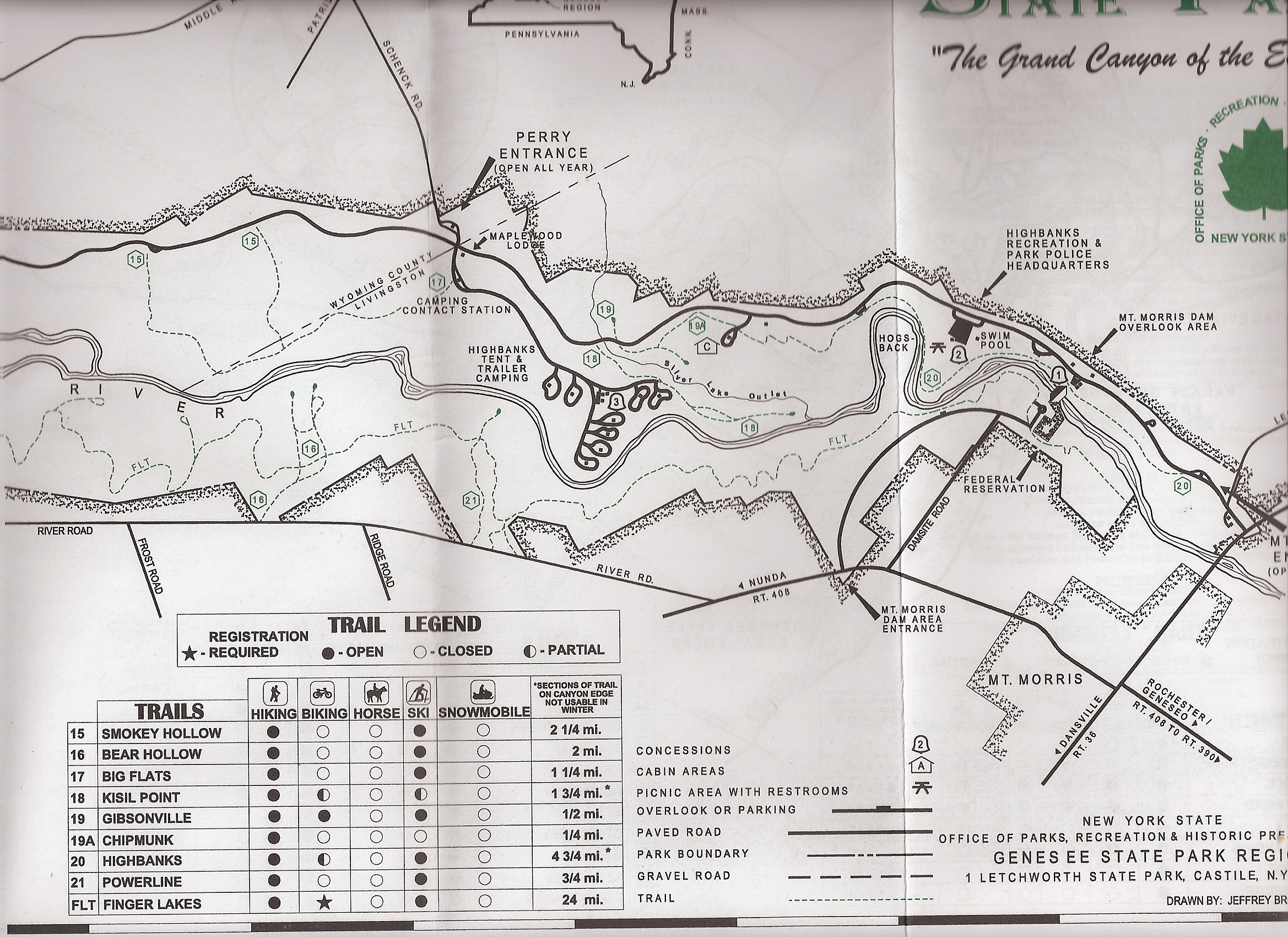
With over 66 miles of marked hiking trails, visitors can really explore all parts of Letchworth State Park. The most popular trails are the Gorge Trail and Highbanks Trail. The best kept secret is the 20+ mile Letchworth Trail on the eastern side of the park. The Gorge & Highbanks Trail travel parallel to the Park Road for most of the time, so you can pick and choose what sections you want to hike. The park trails are numbered from 1 to 21, except for the Letchworth Trail.
Below is a list of the marked hiking trails in Letchworth State Park. Use the links (under construction) to find out more information on each of the trails.
#1 Gorge Trail (7+ miles) - This popular trail travels parallel to the main park road and passes many scenic overlooks including Inspiration Point.
#2 Mary Jemison Trail (2.5 miles) - Take a pleasant woods walk along the trail dedicated to the famous Deh-ge-wan-us, or "White Woman of the Genesee". There are two access points for this trail, one at Council Grounds and the other at a small parking area near the railroad bridge over the main park road.
#2A Hemlock Trail (2.5 miles) - This trail travels off the Mary Jemison Trail near Council Grounds and passes Trout Pond as well as Trailside Lodge on its way to the Castile Entrance Road. This very scenic trail features numerous hemlock trees. The trail does cross a couple of ravines.
#3 Trout Pond (0.75 miles) - Trail travels near Trout Pond. The trail itself is a wide path that was originally an access road. You'll find some small sloped areas, nicely wooded areas and grassy open detours all in a small area.
#4 Birch Trail (0.75 miles) - Trail travels near cabin area B and the group camping area with three branch trails to explore.
#5 Lee's Landing Trail (1.0 miles) - This trail follows the path that was once used to launch wood rafts of lumber for transport downstream to Rochester. It's an easy walk down, difficult climb back. This trail starts off the Gorge Trail near the Footbridge Nature Shop, past cabin area B.
#6 Portage Trail (0.5 miles) - This is an easy trail that follows the gorge edge and has several small overlooks of the gorge including a view directly over the Lower Falls. It ends in lovely woods just above the stone footbridge that connects the east side of the park with the west side. This is the only trail river crossing in the entire length of the park.
Long ago, travelers had to take their canoes out of the water to avoid the three waterfalls. They would put them back in the water either above the upper Falls or below the lower falls, depending on which way they were traveling. The Portage Trail was the path they used.
#6A Footbridge Trail (0.5 miles) - This trail has some stairs and connects the Portage Trail with the Lower Falls area. This is the only hiking bridge over the Genesee River that connects the east side of the state park with the west side. The bridge is an impressive stone structure.
#7 Genesee Valley Greenway Trail (5.75 miles) - The Genesee Valley Greenway Trail (GVG) is a fairly easy hiking trail with a few moderate areas, up and down slopes, but for the most part is relatively flat. It follows the path of the former Genesee Valley Canal which existed along this path from 1836 to 1878, followed by the Pennsylvania Railroad. The remnants of the railroad can be seen including railroad ties and of course the cinders under your feet as you travel along its length.
The Railroad ran from the mid 19th Century to the early 1960’s. The gorge section of the trail offers spectacular views of the gorge as well as the Upper and Middle Falls from short side trails. These views from the eastern side of the state park are views that few visitors to the park ever see. The most spectacular view is of Inspiration Falls when there is water. Most visitors to Letchworth never see this 300+ foot seasonal waterfall. The views are best seen when there are no leaves on the trees as in late fall or early to mid spring. The trail also offers the only views of the 150 foot Deh-ga-ya-soh Falls as well as the 90 foot Timber Tunnel, the hard to see 15 foot Deh-ga-wa-nus Falls, and the usually low flowing 40 foot Bubbling Tier Falls.
Although the trail is open in Winter, it would be very dangerous to roam off trail on snow and ice on the edge of the gorge above the falls or anywhere else. As the trail leaves the gorge area, it passes some of the historic locks which helped the canal barges wind their way north and south along this short lived water way. Hand carved stone blocks, a painstaking job to say the least, stand silent testimony to the early builders and settlers in the Genesee Valley.
The Genesee Valley Greenway Trail coincides briefly with the Letchworth Trail. The GVG continues on both north and south of the park. The trail travels over 80 miles and more information on this great trail can be found on the Friends of Genesee Valley Greenway website.
#8 River Road Trail (2.75 miles) - Is really a dirt road, more than a hiking trail although part of the Letchworth Trail does follow the road briefly. The trail is shown on the official park trail map.
#8A Blue Jay Trail (0.5 miles) - Is a short trail that travels from the Letchworth Trail to the eastern park road near cabin area E.
#9 Dishmill Creek Trail (3.0 miles) - Some of the Dishmill Creek Trail intersects with the Letchworth Trail and with the Trillium Trail. A small waterfall may be viewed and explored on one of the branches of the trail. You may also reach the rocky shore of the Genesee River directly across from the area known as St. Helena where a village once stood and the St. Helena Trail ends.
#10 Big Bend Trail (2.5 miles) - This trail ascends steadily to access the highest point in the Park known as The Knob. It is located on the east side of the park in cabin area E. It is the only multi use trail that one can drive their car or truck on its length. The trail was formally a logging road.
#10A Trillium Trail (0.5 miles) - Despite the name, there are no Trilliums in spring bloom along this short trail. The trail follows the edge of the gorge for a while, then descends into the valley containing Dishmill Creek and terminates at the Genesee River, directly across from St. Helena.
The free park map shows it curving and crossing Dishmill Creek where the trail becomes the Dishmill Creek Trail. This part of the trail can be overgrown and narrow. The main, more used trail continues straight ahead and ends at a small bank on the Genesee River. Be careful of poison ivy along parts of the trail.
#11 Deer Run Trail (1.5 miles) - This trail is found off the main park road at two spots, one near the spur road to Gardeau Overlook. The trail follows the park boundary.
#12 Seneca Trail (0.75 miles) - This trail was formally a part of the St Helena Road. It descends into the gorge to the edge of the Genesee River across from the former village of St Helena.
#13 St Helena Trail (1.25 miles) - This trail descends to the former site of the village of St Helena. For more info on this ghost town, check out the book St. Helena, ghost town of the Genesee, 1797-1954
.
#14 Gardeau Trail (0.5 miles) - This trail leads from the main park road to a scenic overlook. A spur road travels parallel to the trail that takes those who don't want to walk via their cars to another overlook.
#15 Smokey Hollow Trail (2.25 miles) - The trail is located off the main park road at two locations just south of the Perry Entrance to the park. The trail loops down into the gorge and offers a nice view of the Horsetail Falls as well as the Detour Cliff Cascade (when the water is flowing).
#16 Bear Hollow Trail (2.0 miles) - This trail starts as an access trail for the Letchworth Trail, which is reached in 0.4 miles from River Road. The trail branches out just prior to reaching the Letchworth Trail to a couple of overlooks.
#17 Big Flats Trail (1.25 miles) - This trail descends from the Highbanks camping contact station to the Smokey Hollow Trail.
#18 Kisil Point Trail (1.75 miles) - This trail travels from the main park road past Highbanks Campground to Kisil Point. Kisil Point describes the physical feature where the gorge of Silver Lake Outlet meets the gorge of the Genesee River. There is an old picnic area and shelter along the trail as well as the seldom seen Kisil Falls near the park road.
#19 Gibsonville Trail (0.5 miles) - This trail travels in the former village of Gibsonville along the banks of Silver Lake Outlet. There are the remains of an old 1940s CCC camp as well as the 45 foot Gibsonville Falls located just off the trail.
#19A Chipmunk Trail (0.25 miles) - This trail connects the Gibsonville Trail with cabin area C and the Highbanks Trail.
#20 Highbanks Trail (4.75 miles) - This popular trail follows the west rim on the northern part of the state park. The trail starts at the Mt Morris Entrance and ends at cabin area C. The trail has a nice view of the seasonal Craspey Clay Falls.
#21 Powerline Trail (0.75 miles) - This trail follows a power line right of way past the Letchworth Trail to the point where the lines cross the gorge.
#22 Sycamore Trail (0.75 miles) - This trail starts as an access trail for the Letchworth Trail, which is reached in 0.3 miles from River Road. The trail then becomes rough and steep as it descends toward the river. It's a trail that normally doesn't see much travel.
Letchworth Trail (24.0 miles) - This spectacular trail travels along the eastern rim of the gorge with numerous memorable views. This is one of those must do backpacking trails in New York. A great weekend hiking adventure that will be remembered for a lifetime. Follow the yellow blazes.
Footbridge Trail features only bridge over the Genesee River
| Hiking Trail
Maps from Letchworth State Park
Click on the maps above for a larger picture. |
| CNY Hiking HOME PAGE | New York State Parks | Letchworth Trail | Letchworth State Park |