Lackawanna State Forest
Big Pine
Hill Loop
![]()
| Best of the AT in Pennsylvania | Pinchot Trail System |
|
Hiking in Pennsylvania Lackawanna State Forest Big Pine Hill Loop
|
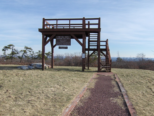
This hike utilizes parts of the Pinchot Trail system, Powder Magazine Trail, Frank Gantz Trail, White Line Trail and Pine Hill Trail to create a 5.2 mile loop. There is an observation tower on the summit of Big Pine Hill that allows 360 degree views. This is a moderate hike with a 347 foot elevation change.
From the parking area, take the Powder Magazine Trail uphill to the junction of the Pine Hill Trail. Turn left and follow Pine Hill Trail for a short time and turn left on the Frank Gantz Trail. At the end of this trail, turn right on the White Line Trail which runs along the state forest boundary. This section of the trail has a stream crossing that you may get your feet wet.
The trail veers right and becomes the Pine Hill Trail and follows the old road until the trail turns right off the road. When you reach a seasonal dirt road, turn right and follow the road to the observation deck for a 360 degree panoramic view of the area. Return to the road until you reach the Pine Hill Trail again, turning right and following trail downhill.
Soon you will reach the junction of the Frank Gantz Trail. Now your retracing your steps back to the parking area. There are parts of this hike where the trails are extremely rocky, many roots and even boggy. The views are worth the hike. There are other opportunities for short, long and backpacking hikes utilizing the Pinchot Trail system in Lackawanna State Forest. Below there are maps and more of a description of this hike.
Directions from Syracuse, NY: I-81 South to Clark Summit, Pa exit 194. Take I-476 South (NE extension of Penn TRPK) to exit 115. Turn right on PA 115 South. Turn left on Meadow Run Road. Turn right on Bear Creek Road aka Thornhurst Road. There is a large parking area on the left just prior to Bear Lake Road. It is 11.7 miles from exit 115 to the parking area. It is about 2.5 hours from Syracuse to Lackawanna State Forest.
Pine Hill observation platform
Mileage Elevation Description 0.0 1915 feet From the parking area follow the Powder Magazine Trail uphill. Soon pass a trail register. This is part of the Pinchot Trail system.
0.4 2014 feet The trail turns right and in 200 feet reach the junction with Pine Hill Trail. Turn left onto Pine Hill Trail. The Powder Magazine Trail continues straight to Pittston Road.
0.7 2019 feet Turn left onto the Frank Gantz Trail.
1.9 2121 feet Reach state forest boundary and turn right onto White Line Trail.
2.3 2112 feet Cross stream.
2.5 2168 feet White Line Trail veers right away from forest boundary.
2.7 2168 feet End of White Line Trail. Junction with the Scrub Oak Trail on your left. Continue straight on old woods road. This is the Pine Hill Trail.
3.4 2184 feet Pine Hill Trail turns right off old road.
3.6 2188 feet Turn right onto seasonal dirt road for side trip to observation deck.
3.8 2260 feet Pine Hill summit and observation deck with 360 degree views. Return down dirt road.
3.9 2188 feet Turn right back onto Pine Hill Trail and descend. Trail very rocky.
4.5 2019 feet Junction on your right with the Frank Gantz Trail. Continue straight.
4.8 2003 feet Reach Powder Magazine Trail and turn right. In 200 feet the trail veers left.
5.2 1915 feet Reach parking area.

| Best of the AT in Pennsylvania | Pinchot Trail System | |
| Pinchot Trail Map (pdf) | Pinchot North Loop | Pinchot South Loop |