Skyline
Drive
![]()
| CNY Hiking HOME PAGE | Shenandoah National Park | Blue Ridge Parkway |
|
Shenandoah National Park Skyline Drive
|
Remember when driving was fun and relaxing? No? Well, believe it or not, your car can be your escape. A slow meander down Skyline Drive in Shenandoah National Park will give you a whole new driving experience. Official ground breaking was July 18, 1931, although the actual field survey began in January of that year.
First section of construction initially was to be from Rapidan Camp to the Skyland Resort, some twenty miles, but evolved into the 34 miles from Swift Run Gap (US 33) to Thornton Gap (US 211). Original funds were allocated by the Federal Drought Relief Administration to employ Virginia farmers and apple pickers suffering from the severe drought impacts on the apple and produce harvests in 1930.
Skyline Drive from Thornton Gap to Swift Run Gap was completed in the summer of 1934 and opened to the public on September 15, 1934. Construction on Skyline Drive was finished on August 29, 1939 and the original drive ran from Front Royal to Jarmin Gap. Originally the Blue Ridge Parkway began at Jarmin Gap, however in 1961 the section of road from Jarmin Gap to Rockfish Gap was deeded to Shenandoah National Park.
Skyline Drive runs 105 miles north and south along the crest of the Blue Ridge Mountains in Shenandoah National Park and is the only public road through the park. You can enter Shenandoah at four places: Front Royal near I-66 and US 340, Thornton Gap at US 211, Swift Run Gap at US 33, and Rockfish Gap at I-64 (also the northern entrance to the Blue Ridge Parkway). It takes about three hours to travel the entire length of the park on a clear day.
As you travel along Skyline Drive you will notice mileposts on the west side (right side if you are traveling south) of the road. These posts help you find your way through the park and help you locate areas of interest. The mileposts begin with 0.0 at Front Royal and continue to 105 at the southern end of the park. The largest developed area, Big Meadows, is near the center of the park, at milepost 51. All park maps and information use these mileposts as a reference.
The maximum speed limit is 35 mph, so you can roll down your windows, feel the breeze and experience every curve and turn of this beautiful drive. There are 75 overlooks that offer stunning views of the Shenandoah Valley to the west or the rolling piedmont to the east. The park purposely leaves the roadsides unmowed so wildflowers put on a show all year long. In early spring you can see trillium peeking through the grass. June’s display of azaleas is spectacular, and cardinal flower, black-eyed susans, and goldenrod keep the color coming right into fall.
Deer, black bear, wild turkey, and a host of other woodland animals call Shenandoah home and regularly cross Skyline Drive in their daily travels. Watch carefully for these animals who may dart across your path without warning. At 35 mph, you’ll stand the best chance of a fun and exciting wildlife encounter rather than an unpleasant wildlife experience! If you want a closer look, be sure to pull completely off the Drive and stay in your vehicle. Remember it is unlawful to feed the wildlife.
RVs, camping trailers, and horse trailers are welcome, but be prepared to shift into low gear. Also, be sure you will clear Marys Rock Tunnel (just south of Thornton Gap entrance from Route 211) at 12’8”. Look below for a closer look at Skyline Drive; with pictures, trail maps, hiking descriptions and links to even more information to assist in your planning your visit to this wonderful place.
Mile Elevation Highlights along Drive (north to south)
0.0 590 feet Start of Skyline Drive off US 340 just outside of Front Royal, Va.
0.05 590 feet Dickey Ridge Trail parking area.
0.6 705 feet Front Royal Entrance Station. Park fee is $15, which is good for 7 days in the park. 1.4 970 feet Parking area on right. There is a 60' waterfall about 100 feet across road (access by walking). 2.0 1150 feet Parking area for the Dickey Ridge Trail crossing 0.15 mile further south. 2.15 1155 feet Dickey Ridge Trail crossing. Parking is 0.15 to the north. 2.8 1390 feet SHENANDOAH VALLEY OVERLOOK 4.6 1940 feet DICKEY RIDGE VISITOR CENTER - Information, publications, slide show, exhibits, telephone, rest rooms, water; Fox Hollow Self-Guiding Trail (1.2 mile loop) (RECOMMENDED $1 guide); access to Dickey Ridge Trail. 4.7 1935 feet DICKEY RIDGE PICNIC AREA - picnic tables, fireplaces, several drinking fountains (turned off in winter), and a comfort station. 5.1 1955 feet SNEAD FIRE ROAD - Snead Farm hike (1.4 mile out & back or 3.2 miles loop) 5.3 1985 feet UNNAMED OVERLOOK 5.7 2090 feet SIGNAL KNOB OVERLOOK
6.8 2085 feet GOONEY RUN OVERLOOK
7.3 1930 feet GOONEY MANOR OVERLOOK
7.9 1790 feet Low Gap. Dickey Ridge Trail crossing. Parking on grass. 9.2 2015 feet Lands Run Gap. Dickey Ridge Trail crossing. Trail to Lands Run Falls (1.2 mile round trip) 10.4 2415 feet Compton Gap. Appalachian Trail crossing. Hike to Compton Peak (2 mile round trip). VIEWS. 10.8 2400 feet INDIAN RUN OVERLOOK
12.35 2350 feet Jenkins Gap. Appalachian Trail access. A nice easy 3.4 mile round trip hike along the AT from here. 12.4 2355 feet JENKINS GAP OVERLOOK
12.5 2360 feet Mount Marshall Trail (horse trail) - parking on side of road or at Jenkins Gap Overlook 0.1 mile to the north. 13.8 2665 feet HOGWALLOW FLATS OVERLOOK
14.2 2745 feet Hogwallow Flats. Appalachian Trail crossing.
14.9 2890 feet BROWNTOWN VALLEY OVERLOOK - Drinking fountain
15.95 3075 feet Appalachian Trail crossing. HIKE: North Marshall via AT. To the viewpoint, round trip 0.75 miles; total climb about 105 feet and HIKE: South Marshall via AT. To the viewpoint: round trip 1.6 miles; total climb about 295 feet. 17.1 2810 feet RANGE VIEW OVERLOOK - this overlook is the superstar of the North Section.
17.6 2665 feet Gravel Springs Gap. Appalachian Trail crossing. 18.4 2675 feet GIMLET RIDGE OVERLOOK
18.9 2805 feet Appalachian Trail crossing. 19.0 2850 feet MOUNT MARSHALL OVERLOOK
19.7 3035 feet LITTLE HOGBACK OVERLOOK - Appalachian Trail access. Short 0.2 mile walk to view point. Take the connecting trail at the north end of the overlook and continue in the same direction on the A.T. to where it makes a sharp right turn. A side trail goes straight ahead here, fifteen yards to the viewpoint.
20.1 3120 feet LITTLE DEVILS STAIRS OVERLOOK
20.8 3385 feet HOGBACK OVERLOOK - Appalachian Trail crossing. This overlook offers a couple of short, easy hikes, as well as a view. It's the longest overlook in the Park; to see the whole view you have to stop somewhere near the middle of it; or stop twice—once at each end.
21.1 3385 feet Appalachian Trail crossing. Hike to Overall Run Falls (6.4 miles Strenuous) 21.9 3105 feet RATTLESNAKE POINT OVERLOOK
22.0 3105 feet Appalachian Trail crossing. 22.2 3105 feet MATHEWS ARM CAMPGROUND - Traces Trail (1.7 mile easy loop hike) 23.9 2430 feet Appalachian Trail crossing. 24.0 2425 feet ELKWALLOW WAYSIDE. Usually open from May to October. Snack bar, campstore, souvenirs, gas, oil, water, toilets. The outdoor telephone is in service all year. The Elkwallow Trail travels 1.75 miles to the Mathews Arm Campground. 24.1 2420 feet ELKWALLOW PICNIC AREA - The one-way road makes a loop around the picnic area and returns to the Drive at Mile 24.2. There are picnic tables and fireplaces; and several drinking fountains, which are drained in winter. The comfort station is on the inside of the loop, near the middle. 25.4 2420 feet Thorton River Trail crossing. 26.4 2410 feet JEREMYS RUN OVERLOOK


26.8 2410 feet Parking Area with access to Appalachian Trail. 27.6 2460 feet THORNTON HOLLOW OVERLOOK
28.2 2470 feet Hull School Trail crossing 28.5 2485 feet BEAHMS GAP OVERLOOK - no views at overlook. Choice of three nice hikes: Appalachian Trail to Pass Mountain or Beahms Gap Loop or Appalachian Trail to Byrds Nest Shelter No. 4 30.1 2460 feet PASS MOUNTAIN OVERLOOK - HIKE: Pass Mountain Overlook Loop. Circuit less than 0.25 mile. Total climb about 50 feet; time required 0:15. A pleasant, very easy walk on a smooth graded trail. Go straight out from the overlook, downhill to a rock ledge. The view here is a little wider than from the overlook. Continue downhill, following the trail around to your left, and return to your starting point via the gate in the fence.
31.4 2305 feet Fire Road & Appalachian Trail crossing. 31.5 2304 feet Thornton Gap - US 211 interchange. End of Northern District. Start Central District. 31.6 2304 feet Panorama - restaurant closed. AT access. 32.2 2510 feet Marys Rock Tunnel 32.4 2510 feet TUNNEL PARKING OVERLOOK
32.9 2710 feet BUCK HOLLOW OVERLOOK
33.0 2770 feet HAZEL MOUNTAIN OVERLOOK

33.5 2840 feet Meadow Spring Parking Area - HIKE: Marys Rock Summit. Round trip 2.8 miles; total climb about 830 feet. Magnificent views. A moderate hike, with a few rough spots and a few short stretches that are moderately steep. 35.1 3320 feet PINNACLES OVERLOOK
36.4 3320 feet JEWELL HOLLOW OVERLOOK - Appalachian Trail access.
36.7 3350 feet Pinnacles Picnic Area - Appalachian Trail access. Pinnacles Picnic Grounds Hike on AT (2 miles roundtrip). 37.9 3000 feet Parking Area - Appalachian Trail access 38.4 3100 feet Nicholson Hollow Trail crossing. 38.6 3100 feet STONY MAN MOUNTAIN OVERLOOK - Appalachian Trail access.
39.1 3110 feet Parking Area - Appalachian Trail access. HIKE: Little Stony Man. Round trip 0.9 mile; total climb about 270 feet; time required 1:00. Sheer cliffs, with good views. An easy hike, though part of the trail is rather rough. 39.7 3380 feet HEMLOCK SPRINGS OVERLOOK
40.5 3595 feet THOROFARE MOUNTAIN OVERLOOK
41.7 3680 feet SKYLAND, NORTH ENTRANCE (highest point on Drive). Food, lodging, gifts, taproom. HIKE: Stony Man Nature Trail. Round trip 1.6 miles; total climb about 340 feet. An easy, gradual climb to the cliffs of Stony Man summit; part of the trail is rather rough. The hike is self-guiding, using numbered posts and a pamphlet. The pamphlet dispenser is beside the trail at its beginning, in the corner of the parking area nearest the Drive. 42.5 3515 feet SKYLAND, SOUTH ENTRANCE. Food, lodging; hikes, stables, horseback riding. HIKE: Millers Head. Round trip 1.6 miles; total climb about 450 feet. A fairly easy hike on a good, graded trail, down a rocky ridge to an observation platform with a fine, nearly 360-degree view. 42.6 3510 feet Whiteoak Canyon Parking. HIKE: Whiteoak Canyon to first falls. Round trip 4.6 miles; total climb about 1,040 feet. 43.3 3360 feet TIMBER HOLLOW OVERLOOK - Appalachian Trail access.
44.4 3550 feet CRESCENT ROCK OVERLOOK - Appalachian Trail access. From the south end of the wall, a graded trail goes a hundred yards to Crescent Rock for a better view. Below is a panoramic view of Crescent Rock.
HIKE: Bettys Rock. Round trip 0.7 mile; total climb about 150 feet. An easy walk to a ledge with a wide view. The trail begins at the north end of the sidewalk in front of the wall, and climbs steadily and easily. BOTH short hikes are recommended from this overlook. Below is a panoramic view of Betty's Rock.
45.0 n/a WHITE OAK FIRE ROAD, east side, 50 yards south of the milepost. There's room to park two cars without blocking the fire road. From here, the walk to the first falls in Whiteoak Canyon is somewhat shorter and easier than from the Whiteoak parking area, Mile 42.6. The round trip from here is 3.8 miles, compared to 4.6 from the parking area; and the total climb is about 840 feet, compared to 1,040. But this is just a dirt road through the woods—not at all scenic. 45.6 3365 feet Hawksbill Gap. Appalachian Trail access. 46.5 3585 feet OLD RAG VIEW OVERLOOK


46.7 3635 feet Upper Hawksbill Parking Area - HIKE: Hawksbill Mountain. Round trip 2.1 miles; total climb about 520 feet. A fairly easy hike on a graded trail and a fire road. Good views from the summit. 48.1 3285 feet SPITLER KNOLL OVERLOOK - Appalachian Trail access.


49.0 3140 feet FRANKLIN CLIFFS OVERLOOK
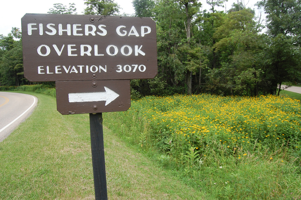
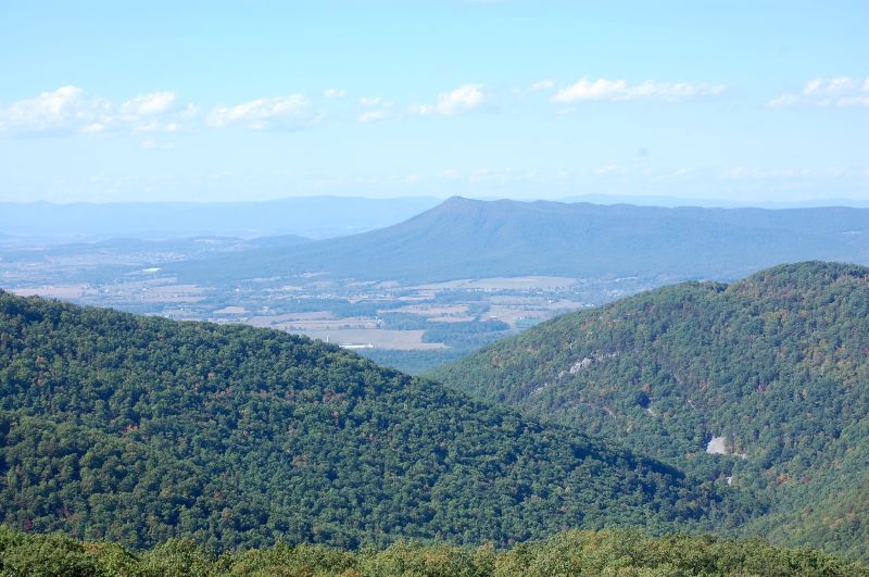
49.4 3070 feet FISHERS GAP OVERLOOK - Appalachian Trail access. HIKE - AT from Fishers Gap Overlook. HIKE: Rose River Falls. Round trip 2.7 miles; total climb about 720 feet. A not-too-difficult hike to a rather small but very pretty waterfall.


50.7 3425 feet Dark Hollow Falls Parking Area - HIKE: Dark Hollow Falls. Round trip 1.4 miles; total climb about 440 feet. Take the trail at the north end of the parking area. 51.0 n/a Big Meadows North Entrance - To reach the Visitor Center or to walk in the meadow, turn right here, then left into the parking area. 51.2 3510 feet Big Meadows South Entrance - Turn in here for food and lodging, gasoline, camping, hiking and picnicking. HIKING MAP OF BIG MEADOW AREA. HIKE: Blackrock. A very easy hike to a high point with a good view. The trail, marked by a sign, starts at the far end of the parking area beyond the Dining Hall. Round trip from the Dining Hall, 0.4 mile; from the end of the parking area, less than 0.2 mile. Total climb about 60 feet. HIKE: Story-of-the-Forest Nature Trail. Circuit 1.8 miles; total climb about 290 feet. An easy, self-guiding hike, with interpretive posts beside the trail for about two-thirds of its length. The trail starts at the Byrd Visitor Center and passes through a forest in various stages of succession. It ends at the Big Meadows Wayside, near the Visitor Center parking area. 51.3 n/a Rapidan Road - The road goes 6.3 miles to Camp Hoover and, eventually, to Criglersville. Camp Hoover is easier to walk to from Milam Gap, Mile 52.8. 51.4 n/a Service Road & Parking Area - HIKE: Lewis Falls. Round trip 2.0 miles; total climb about 795 feet.

51.5 3465 feet TANNERS RIDGE OVERLOOK
51.6 3465 feet Tanners Ridge Fire Road - Appalachian Trail access & cemetery. 52.8 3230 feet Milam Gap - Appalachian Trail & Camp Hoover Hikes access. HIKE - AT Milam Gap.


53.2 3250 feet NAKED CREEK OVERLOOK
54.4 3265 feet HAZELTOP RIDGE OVERLOOK

55.1 3235 feet Bootens Gap - Appalachian Trail access. 55.6 3235 feet THE POINT OVERLOOK
56.4 n/a Bearfence Mountain Parking Area - HIKE: Bearfence Mountain. You have two options for this hike. One with a rock scramble and one with out a rock scramble. You have a 360 degree view from the summit if you choose the rock scramble hike. One of only 4 or 5 places in the park with such a view! RECOMMENDED HIKE!
56.8 n/a Parking area - Appalachian Trail access. 57.5 3390 feet Lewis Mountain Facilities. Picnic area, cabins, conducted walks and campfire talks, camp store, telephone, campground, showers, A.T. access. Open about mid-April through October.
59.1 3125 feet THE OAKS OVERLOOK
59.5 3125 feet Pocosin Fire Road - Appalachian Trail access. 61.3 3345 feet BALDFACE MOUNTAIN OVERLOOK
61.8 n/a Service Road - Appalachian Trail access. 62.7 2950 feet SOUTH RIVER OVERLOOK


62.8 2950 feet South River Picnic Area - Appalachian Trail access & hikes to South River Falls. HIKE - AT South River Picnic Grounds. HIKE: South River Falls. Round trip 2.6 miles, total climb about 850 feet. A moderately easy hike; the return trip is a steady climb. 63.1 n/a Service Road 63.2 n/a Parking Area - Dean Cemetery. There are more than 100 graves here. The oldest is that of James Dean—born January 15, 1797; died May 22, 1862. 64.4 2560 feet HENSLEY HOLLOW OVERLOOK

64.9 n/a Parking pullout 65.5 2365 feet Swift Run Gap - Appalachian Trail crossing & US 33 interchange. This is the end of the "Central District" and the start of the "Southern District" of Shenandoah National Park. 66.7 2635 feet Hightop Mountain Parking Area - HIKE: Hightop Mountain. Round trip 3.0 miles; total climb about 935 feet. Outstanding views. Recommended Hike, worth the climb.


67.2 2715 feet SWIFT RUN OVERLOOK
67.8 2705 feet SANDY BOTTOM OVERLOOK

68.6 2620 feet Smith Roach Gap - Appalachian Trail access. 69.3 2455 feet BACON HOLLOW OVERLOOK
69.9 2295 feet Powell Gap - Appalachian Trail crossing.
70.6 2500 feet EATON HOLLOW OVERLOOK
71.2 2445 feet ROCKY MOUNT OVERLOOK

72.2 2345 feet BELDOR HOLLOW OVERLOOK
73.2 2255 feet Simmons Gap - Appalachian Trail crossing.
74.4 2455 feet LOFT MOUNTAIN OVERLOOK


75.2 2535 feet Pinefield Gap - Appalachian Trail crossing. No safe parking at this crossing for the AT. 76.1 n/a Rocky Mount Trail - HIKE: Rocky Mount. Round trip 6.9 miles; total climb about 2,065 feet. This is a VERY strenuous hike; near the summit, the trail is steep and rough. Views at summit and along trail. 76.2 2770 feet TWO MILE RUN OVERLOOK

76.9 2844 feet BROWN MOUNTAIN OVERLOOK
77.5 2890 feet IVY CREEK OVERLOOK - Appalachian Trail access.


78.1 2860 feet ROCKYTOP OVERLOOK
79.5 n/a LOFT MOUNTAIN AREA - Loft Mountain Wayside, open from early May to late October. It offers a telephone, food, souvenirs, gasoline, water, and accessible restrooms. During the summer the Park operates an Information Center in the old gas station building. You can get information and backcountry permits here. The rest of the Loft Mountain development is up on Big Flat Mountain, a mile or more from the Drive via the paved road opposite the north end of the Wayside parking area. Facilities—normally open late May to late October—includes a campground, picnic area, amphitheater, campstore, accessible laundry and showers, and trailer sewage disposal. HIKE - Loft Mountain & Frazier Discovery Trail (1.3 mile loop) RECOMMENDED. HIKE - AT from Loft Mountain Wayside. There are a lot of views along AT as it winds around the camping area. 81.1 2860 feet Doyles River Parking Area - Appalachian Trail access. HIKE - Doyles River Falls. HIKE - AT from Doyles River Parking Area. 81.2 2860 feet BIG RUN OVERLOOK - This is one of the most beautiful overlooks in the Park.


81.9 2875 feet DOYLES RIVER OVERLOOK - Appalachian Trail access. The overlook is about 100 yards off the Drive. The entrance road makes a loop around the island, which has shade trees and picnic tables.
82.0 2875 feet VIEWPOINT - There's parking space in the grass on the east side of the Drive, about 50 yards south of the milepost. Look out for a culvert near the north end of the grassy strip. From the west side of the Drive you have a clear view into Big Run. 82.2 2800 feet Appalachian Trail crossing. Limited parking on side of road. 83.0 2600 feet Browns Gap - Appalachian Trail crossing. 83.7 2769 feet DUNDO OVERLOOK
84.1 2790 feet Jones Run Parking Area - HIKE: Jones Run Falls. Round trip 3.4 miles; total climb about 915 feet. A not very difficult hike on a good trail to an attractive waterfall. 84.3 2810 feet Appalachian Trail crossing. 84.8 n/a Blackrock Parking Area - HIKE: Blackrock Summit. Round trip 1.0 miles; total climb about 175 feet. An easy hike with outstanding views. RECOMMENED HIKE. 86.8 2530 feet TRAYFOOT MOUNTAIN OVERLOOK 87.4 2320 feet Blackrock Gap - Appalachian Trail access. 88.6 2580 feet HORSEHEAD OVERLOOK
88.9 2620 feet Appalachian Trail crossing. 90.0 2730 feet Riprap Parking Area - Riprap Trail, AT access. HIKE: Chimney Rock. Round trip 3.4 miles; total climb about 830 feet. Good trail, fine views. RECOMMENED HIKE. 91.4 2920 feet RIPRAP OVERLOOK
92.0 2975 feet MOORMANS RIVER OVERLOOK
92.1 2980 feet Wildcat Ridge Parking Area - Appalachian Trail access. HIKE - AT from Wildcat Ridge Parking Area. 92.4 3000 feet Appalachian Trail crossing. 92.6 2985 feet CRIMORA LAKE OVERLOOK

93.7 2720 feet TURK MOUNTAIN OVERLOOK
94.1 2610 feet Turk Gap - Parking & Appalachian Trail access. HIKE: Turk Mountain Summit. Round trip 2.2 miles; total climb about 690 feet. VIEWS. 95.3 2200 feet SAWMILL RUN OVERLOOK - Appalachian Trail crossing. HIKE - AT from Sawmill Run Overlook.

95.9 2215 feet SAWMILL RIDGE OVERLOOK 96.8 2175 feet Jarman Gap - Appalachian Trail access. 97.4 n/a Powerline Crossing. 98.9 2480 feet CALF MOUNTAIN OVERLOOK - As you approach the overlook the road appears to go right out into the sky. This is a long overlook with a 300-degree wrap-around view. To see all of it you should park your car and walk from one end of the overlook to the other.
99.5 2530 feet Beagle Gap - Appalachian Trail crossing & hikes. HIKE #1: Calf Mountain Summit. Round trip 2.1 miles; total climb about 495 feet. An easy hike through partly open former pasture. Take the A.T. on the east side of the Drive. It ascends along the right flank of the first crest, and continues along the semi-open saddle, where it's marked by white blazes on the rocks. The high point of the trail, on the second crest of Calf Mountain (elevation 2,975 feet) is your destination. From there you have a fine view straight ahead of the summit of Bucks Elbow Mountain, with the radio installations on top. If you follow the trail a few yards more, you can see farther to the left, with a view of the whole length of the Moorman River valley. HIKE #2: Bear Den Mountain. Round trip 1.2 miles; total climb about 355 feet. Take the A.T. on the west side of the Drive, and climb through mostly open fields to the summit (elevation 2,885 feet). The towers serve numerous communication systems. There are views on both sides of the ridge.
99.8 2495 feet BEAGLE GAP OVERLOOK
102.1 2440 feet McCormick Gap - Appalachian Trail crossing. 102.4 2455 feet MCCORMICK GAP OVERLOOK

104.6 2070 feet ROCKFISH GAP ENTRANCE STATION 105.1 n/a Shenandoah National Park Boundary. Start Blue Ridge Parkway, end Skyline Drive.
105.2 1900 feet Appalachian Trail crossing.
105.4 1900 feet Rockfish Gap. I-64 & US 250 interchange. Continuing south on Blue Ridge Parkway, it's 469 miles to Great Smoky Mountain National Park.
| CNY Hiking HOME PAGE | Shenandoah National Park | Blue Ridge Parkway |