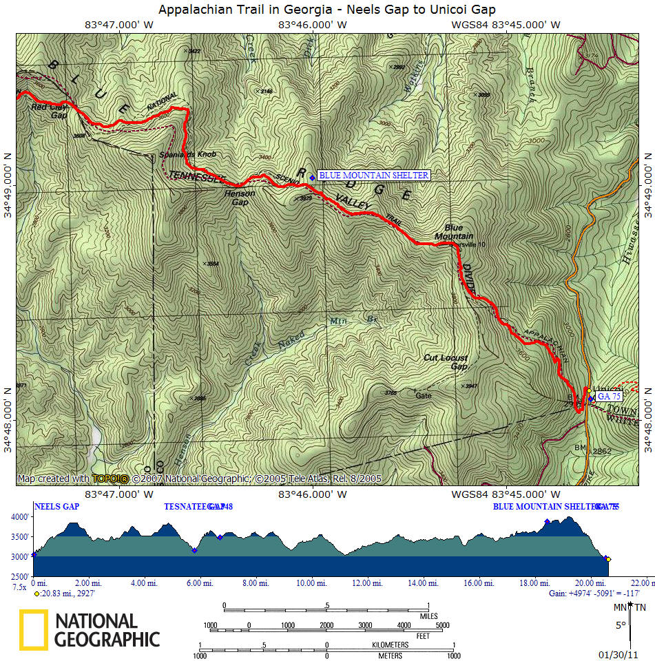
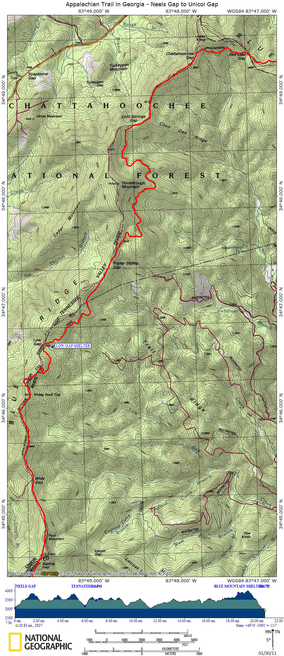
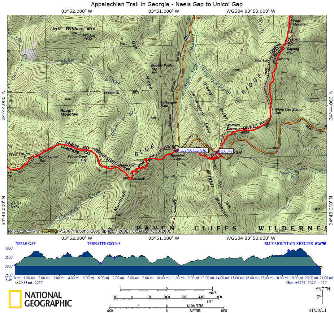
Appalachian Trail in Georgia
Unicoi Gap to Dicks Creek Gap
|
|
|
Unicoi Gap (GA 75) to Dicks Creek Gap (US
76)—16.1 Miles
Brief Description of Section
While much of this section is on well-graded trail, it contains
some of the longest climbs and highest peaks of any Georgia section.
From Dicks Creek Gap (2,675 feet), the Trail ascends Powell Mountain (3,850
feet) and Kelly Knob (4,276 feet), then loses elevation through a series of
ascents and descents until it reaches “The Swag of the Blue Ridge” (3,400 feet),
a wide, low section. Beyond, the Trail ascends Tray Mountain (4,430 feet),
descends to Indian Grave Gap (3,113 feet), and climbs Rocky Mountain (4,017
feet), before descending to Unicoi Gap (2,949 feet).
The Trail between Addis Gap and Tray Gap is now included in the Bobcat
Wilderness Area.
Points of Interest
The major points of interest are Tray Mountain (4,430 feet), with
a splendid viewpoint, and “The Swag of the Blue Ridge” (3,400 feet), a long,
broad ridgecrest with only moderate elevation change for more than three miles.
In the 1960s, when the Georgia A.T. was threatened with extinction by a proposed
extension of the Blue Ridge Parkway, GATC battled doggedly for, and won,
preservation of “The Swag of the Blue Ridge” because of its unique qualities.
Since the 1968 passage of the National Trails System Act and the designation of
the Appalachian Trail as the first national scenic trail, the Georgia A.T.,
including the Swag, has been afforded protection from roads and other
development.
The crest of Tray Mountain (4,430 feet) offers superb vistas to the south and
southeast. Tray Mountain is probably the southernmost breeding area in the
United States for Canada warblers. Directly south is Yonah Mountain. The
isolated peak to the southeast is Curruhee Mountain, near Toccoa, Georgia.
Farther north on the Trail are views of the Blue Ridge. Brasstown Bald, the
highest peak in Georgia, is the prominent peak to the northwest. Rabun Bald, the
second-highest peak, is to the northeast. The Nantahala Range can be seen
directly to the north in North Carolina.
Between Tray Gap and Indian Grave Gap is an area called the “cheese factory.”
This was the site of a remote mountain farm operated by a transplanted New
Englander in the early nineteenth century. For an interesting account of the old
“cheese factory” and of “Trail Mountain” (Tray Mountain), read Charles Lanman’s
Letters from the Allegheny Mountains, published in 1849.
Road Approaches
Dicks Creek Gap is located on U.S. 76, 18 miles west of Clayton
and 11 miles east of Hiawassee, which has most services.
In Addis Gap, 5.3 miles south of Dicks Creek Gap, a fire road, USFS 26, leads
east about eight miles to GA 197 at Wildcat Creek near Lake Burton. To the west
of Addis Gap, the road, impassable by car near the gap, leads about five miles
to GA 75 north of Unicoi Gap.
Unpaved USFS 79 leads southeast from Tray Gap to join the Clarkesville-Lake
Burton Road (GA 197). To the southwest, it leads to GA 75, north of Robertstown.
This road was an old circuit road connecting Helen with Clarkesville and is
usually passable by cars.
In Indian Grave Gap, unpaved, rough USFS 283 leads left (when hiking north to
south) to the Tray Mountain Road (USFS 79) from GA 75, north of Robertstown to
Tray Gap, and right to GA 75 north of Unicoi Gap.
The southern end of this section, Unicoi Gap, is located on GA 75, 10 miles
north of Helen and 14 miles south of Hiawassee. Parking is available.
Shelters and Campsites
This section has two shelters. Deep Gap Shelter is 3.5 miles
south of Dicks Creek Gap and approximately 0.3 mile from the A.T. at the gap.
Tray Mountain Shelter, near the summit of Tray Mountain, is 10.6 miles from the
northern end of the section.
Good water sources are adjacent to both shelters. In addition, several streams
cross the Trail. Water also can be found at Addis Gap.
At the site of the old “cheese factory” near Tray Mountain Road is a spring.
Supplies, Services, and Accommodations
At the northern end, in Dicks Creek Gap, it is 11 miles west to
Hiawassee and 18 miles east to Clayton for supplies. The Blueberry Patch, an
organic farm 3.5 miles west on U.S. 76, offers lodging (hostel), laundry,
shower, breakfast, and shuttle back to the A.T. only February 15 to May 15 and
to southbound through-hikers on request; (706) 896-4893.
At the southern end, Unicoi Gap, it is eight miles south to Robertstown, nine
miles south to Helen, with all services, and 14 miles north to Hiawassee for
supplies.
No public transportation is available through either Dicks Creek Gap or Unicoi
Gap. Call ATC headquarters, (304) 535-6331, for a list of available shuttles.
Trail Description, North to South
Miles Data
0.0 From U.S. 76 in Dicks Creek Gap (2,675 feet), follow Trail south on old road
for about 50 yards. Bear left off road, and ascend gradually on right side of
ridge, then on left side. In first mile, cross several small streams. Pass to
left (east) of Snake Mountain.
1.2 Reach Moreland Gap (3,050 feet). Obscure trail to right (west) leads from
Moreland Gap along Swallow Creek about five miles to Lower Hightower Church at
the Osborne settlement on U.S. 76. From Moreland Gap, bear left, ascending
steadily on left (eastern) side of ridge. Continue on more gradual slope along
broad ridgetop.
2.2 Reach top of Powell Mountain (3,850 feet). Descend slightly.
2.4 Reach McClure Gap. Ascend. At top of slope, blue-blazed trail to left leads
to fine view. Continue along ridgetop. Pass to left of Wolfstake Knob, then to
right of Whiteoak Stamp. Descend.
3.5 Reach Deep Gap (3,550 feet). Look for blue-blazed trail to left leading 0.3
mile to Deep Gap Shelter and spring. On Trail, ascend steadily, and pass to
right of Dismal Knob.
4.0 Cross to left side of ridge in shallow gap.
4.2 Reach crest of Kelly Knob. Summit (4,276 feet) is about 0.2 mile to right.
This is the highest peak between the North Carolina line and Tray Mountain and
one of the two peaks of Double Spring Knob. Descend steadily around southwest
slope. Cross over small knoll.
5.3 Reach Addis Gap (3,304 feet). Water may still be found 0.5 mile from fire
road to the left at old shelter site. From gap, begin ascent along ridgecrest,
soon swinging to right (western) side of ridge.
5.9 Return to ridgecrest, and begin descent.
6.1 Cross Sassafras Gap (3,500 feet). Spring is about 150 yards downhill to left
(east). Ascend around left side of ridge. Regain ridgetop, and continue to
ascend around eastern side of Round Top (3,964 feet).
6.5 Cross over shoulder of Round Top, and descend. Continue along ridgetop,
generally descending.
7.2 Cross Blue Ridge Swag (3,400 feet), lowest gap in this section. Begin long
climb, generally ascending on or just below ridgecrest.
8.4 Swing around right (western) side of Young Lick Knob (3,800 feet). Descend
along eastern side of ridge.
8.9 Reach Steeltrap Gap (3,500 feet). Ascend, then descend.
9.4 Pass Wolfpen Gap (3,550 feet). Ascend, pass to right of knob, and descend.
10.1 Reach gap (3,760 feet). Begin ascent of Tray Mountain, along left (eastern)
side of ridge.
10.6 Reach junction of A.T. with blue-blazed trail to right, which leads about
0.2 mile to Tray Mountain Shelter, built by USFS in 1971. On right of
blue-blazed trail are excellent views from the rocky ledges. Spring is
approximately 800 feet downhill to right of shelter. Bear left on Trail, and
continue ascent.
10.9 Reach small, rocky summit of Tray Mountain (4,430 feet), with excellent
views. This is an outstanding peak of the Georgia Blue Ridge. Descend by
switchbacks.
11.7 Reach Tray Mountain Road, USFS 79, in Tray Gap (3,847 feet). Cross road,
and enter woods on path to left of parking area. Continue along ridge.
11.9 Rocky cliff overlook to the left, with fall and winter views. Descend.
12.5 Reach gap. To right is site of the old “cheese factory.” (See “Points of
Interest.”) Farther right about 50 yards is Tray Mountain Road with a spring.
Ascend slightly, then descend through laurel and rhododendron thickets.
12.7 Cross Tray Mountain Road, USFS 79. Continue descent.
13.4 Reach unpaved road in Indian Grave Gap (3,113 feet). To right along road is
blue-blazed trail, which rejoins A.T. in about 1.8 miles, just north of Unicoi
Gap. (This blue-blazed trail and the A.T. provide an excellent one-day loop
hike.) Cross road, and ascend around southern side of ridge.
14.0 Come into small saddle, bear left, and begin ascent of Rocky Mountain.
Cross to southern side of ridge, where rocky slopes afford views to south.
14.8 Reach summit of Rocky Mountain (4,017 feet). Continue along crest; descend.
15.2 Pass junction with side (blue-blazed) trail, which leads back to Indian
Grave Gap.
15.5 Cross stream.
16.1 Reach Unicoi Gap (2,949 feet) and GA 75. To continue on A.T., go to
northern end of parking area, and cross highway.
Trail Description, South to North
Miles Data
0.0 From GA 75 in Unicoi Gap (2,949 feet), cross to southern end of parking
area, climb several steps, and ascend, climbing steadily along left side of
ridge.
0.6 Reach stream that crosses Trail. Continue climb.
0.9 Reach shoulder (3,600 feet) of Rocky Mountain. Blue-blazed trail to left
leads westward and reconnects with A.T. in Indian Grave Gap. This blue-blazed
trail, together with the A.T., makes an excellent one-day loop hike. To continue
on Trail, bear right, and climb steadily.
1.2 Reach crestline of Rocky Mountain (3,960 feet). Continue on crest.
1.3 Reach summit of Rocky Mountain (4,017 feet). Bear slightly to right, leaving
crest, and descend along southern side of ridge. Rocky slopes afford views to
south. Cross to northern side of ridge, and descend more steeply.
2.1 Reach small saddle, bear right, and continue descent around southern side of
ridge.
2.7 Reach unpaved road in Indian Grave Gap (3,113 feet). To left along road is a
blue-blazed trail that rejoins A.T. just north of Unicoi Gap. Cross road, and
ascend gradually through rhododendron, laurel thickets, and beds of galax.
3.4 Cross Tray Mountain Road, USFS 79. Continue to climb, then descend slightly.
3.6 Reach open gap. To left of Trail is the site of the old “cheese factory”—
see “Points of Interest.” To left about 200 feet is Tray Mountain Road. Nearby
is a spring. Ascend, and continue on ridge.
4.2 Reach rocky cliff and overlook to the right of Trail, with fall and winter
views.
4.4 Reach road, USFS 79, in Tray Gap (3,847 feet). Cross road, and ascend by
switchbacks.
5.2 Reach open, rocky summit of Tray Mountain (4,430 feet), with excellent
views. Beyond, Trail is rough, rocky, and steep.
5.5 Reach blue-blazed trail that leads approximately 0.2 mile to Tray Mountain
Shelter, built by USFS. Spring is approximately 800 feet downhill to right of
shelter. Bear right on Trail, and descend.
6.0 Reach gap (3,760 feet). Pass to left of knob, and descend.
6.7 Pass Wolfpen Gap (3,550 feet). Skirt western side of ridge, and descend.
7.2 Pass Steeltrap Gap (3,500 feet). Ascend along eastern side of ridge.
7.7 Swing around left (western) side of Young Lick Knob (3,800 feet). Continue
along ridge.
8.5 Begin descent into the “Swag of the Blue Ridge.”
8.9 Cross Blue Ridge Swag (3,400 feet), lowest gap in the general area. Continue
along ridge, generally ascending.
9.6 Continue around right (eastern) side of Round Top (3,964 feet), which is the
eastern peak of Dismal Mountain. Regain ridgetop, and descend on eastern side of
ridge.
10.0 Reach Sassafras Gap (3,500 feet). Off Trail to right, or northeast, is
spring about 150 yards downhill. After rounding ridge, descend.
10.8 Reach Addis Gap (3,304 feet). A shelter was formerly located 0.5 mile down
fire road to right; water may still be found there. To continue on A.T. from
Addis Gap, cross over knoll, then begin long climb up ridge to Kelly Knob.
11.9 Reach crest of Kelly Knob (4,276 feet), highest peak between Tray Mountain
and North Carolina line and one of the two peaks of Double Spring Knob. Summit
is about 0.2 mile to left. Descend right (eastern) side of ridge.
12.1 In shallow gap, cross to left (western) side of ridge. Pass to left of
Dismal Knob.
12.6 Descend to Deep Gap (3,550 feet). Look for blue-blazed trail to right
leading about 0.3 mile to Deep Gap Shelter and spring. Continue straight ahead
from Deep Gap, passing first to left of Whiteoak Stamp, then to right of Wolf
Stake Knob. Follow ridgecrest.
13.5 Reach blue-blazed trail to right leading to fine view. Descend.
13.7 Reach McClure Gap.
13.9 Reach broad top of Powell Mountain (3,850 feet). From top, descend around
right (eastern) side.
14.9 After long descent, enter Moreland Gap (3,050 feet). Obscure trail to left
leads along Swallow Creek for about five miles to Lower Hightower Church at the
Osborne settlement on U.S. 76. From Moreland Gap, bear right, descend along old
roadbed, and continue on eastern side of Snake Mountain. Cross several small
streams in last mile of descent.
16.1 Reach Dicks Creek Gap (2,675 feet) and U.S. 76. State highway department
picnic area is located in gap. To continue on A.T., cross highway, and ascend
along stream.
| AT - Georgia | Appalachian Trail | CNY Hiking Home |
|
|