Massachusetts
![]()
| CNY Hiking HOME PAGE | Appalachian Trail | AT - Sages Ravine | AT - East Mountain |
| AT - Upper Goose Pond | AT - Finerty Pond | AT - Mount Greylock | AT in Vermont |
|
Appalachian Trail Massachusetts
|
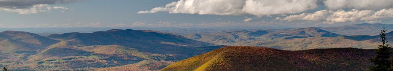
The Appalachian Trail travels 90 miles in Massachusetts as the trail winds through the Berkshires. The trail passes over the highest point in the state at Mount Greylock with an elevation of 3491 feet. The trail travels over hills, valleys and through towns and hamlets of the Berkshires. The AT passes through the towns of Dalton and Cheshire.
You'll find a number of memorable places along the Appalachian Trail in Massachusetts including Sages Ravine, Race Mountain, Mount Everett, Jug End, Housatonic River, East Mountain, Benedict Pond, The Ledges, Upper Goose Pond, Beckett Mountain, Finerty Pond, Bald Top, Warner Mountain, Gore Pond, The Cobbles, Saddle Ball Mountain, Mount Greylock and Eph's Lookout. You'll find blueberries in season near Becket.
Use the links above to explore different sections of the AT in Massachusetts (links under construction). Look below for a detailed description of key points along the Appalachian Trail in Massachusetts. We recommend purchasing any of the books below for those looking for more information on hiking the Appalachian Trail in Massachusetts:
Appalachian Trail Guide to Massachusetts-Connecticut (Official Appalachian Trail Guides)
Exploring the Appalachian Trail Hikes in Southern New England
AMC Massachusetts Trail Guide
Massachusetts & Rhode Island Trail Guide
Appalachian Trail GPS Tracks Get the complete GPS Tracks for the AT in Massachusetts for ONLY $1.97! This .gpx file includes waypoints for all trail shelters along the trail in Massachusetts and many of the official AT parking areas. Use the BUY NOW button below and we'll send you the file via e-mail! Happy Hiking!
Appalachian Trail Hiking Guide
Massachusetts
....coming soon
Miles from Springer Mtn Elevation Key points along the Appalachian Trail in Massachusetts 1503.0 1800 feet Connecticut/Massachusetts State Line 1503.1 1360 feet Sages Ravine Brook Campsite 1503.7 1340 feet Sages Ravine 1505.0 1750 feet Laurel Ridge Campsite 1506.8 2365 feet Race Mountain 1507.9 1950 feet Race Brook Falls Trail 1508.6 2602 feet Mount Everett 1509.3 2050 feet Guilder Pond Picnic Area 1509.7 1880 feet The Hemlock Shelter 1509.8 1885 feet Glen Brook Shelter 1510.4 1750 feet Elbow Trail 1512.1 1750 feet Jug End 1513.2 890 feet Jug End Road 1514.1 810 feet MASS 41, ATC Kellogg Conservation Center (South Egremont, MA 01258) 1515.9 700 feet South Egremont Road, Shays Rebellion Monument 1517.7 700 feet US 7 (Sheffield, MA 01257) (Great Barrington, MA 01230) 1518.6 720 feet Housatonic River 1520.6 1150 feet Homes Road 1522.0 1800 feet East Mountain 1524.1 1540 feet Tom Leonard Shelter 1525.2 1150 feet Lake Buel Road 1526.1 1050 feet MASS 23 (Monterey, MA 01245) 1527.1 1550 feet Blue Hill Road 1528.1 1620 feet Benedict Pond 1528.7 1820 feet The Ledges 1529.4 1720 feet Mount Wilcox South Shelter 1531.2 1950 feet Mount Wilcox North Shelter 1531.8 1800 feet Beartown Mountain Road 1535.0 1200 feet Fernside Road 1535.3 1000 feet Shaker Campsite 1537.1 930 feet Jerusalem Road (Tyringham, MA 01264) 1538.2 930 feet Tyringham Main Road 1540.1 1800 feet Webster Road 1542.5 1650 feet Goose Pond Road 1544.4 1500 feet Upper Goose Pond 1545.2 1483 feet Upper Goose Pond Cabin 1546.4 1400 feet I-90 1546.5 1400 feet Greenwater Brook 1546.8 1400 feet US 20 (Lee, MA 01238) 1547.6 1750 feet Tyne Road 1548.1 2180 feet Beckett Mountain 1549.9 1900 feet Finerty Pond 1552.2 1850 feet County Road 1552.4 2040 feet Bald Top 1554.0 1930 feet October Mountain Shelter 1554.7 1960 feet West Branch Road 1556.2 2000 feet Washington Mountain Road, Pittsfield Road (Becket, MA 01223) 1558.2 1950 feet Stream 1559.4 1850 feet Blotz Road 1560.1 2050 feet Warner Road 1562.8 1860 feet Kay Wood Shelter 1563.1 1650 feet Grange Hall Road 1565.2 1199 feet CSX Railroad 1565.8 1200 feet MASS 8, MASS 9 (Dalton, MA 01226) 1566.8 1180 feet Gulf Road 1570.5 2100 feet Crystal Mountain Campsite 1570.9 2050 feet Gore Pond 1573.4 1850 feet The Cobbles 1574.8 950 feet Church Street, Hoosic River (Cheshire, MA 01225) 1574.9 970 feet Hiker Kiosk 1575.3 990 feet MASS 8 (Adams, MA 01220) 1576.1 1350 feet Outlook Avenue 1578.8 2350 feet Old Adams Road 1579.7 2750 feet Mark Noepel Shelter 1580.3 3150 feet Jones Nose Trail, Saddle Ball Mountain 1582.5 3290 feet Notch Road, Rockwell Road 1583.0 3491 feet Mount Greylock, Bascom Lodge, Summit Road 1586.2 3400 feet Notch Road 1586.3 2325 feet Wilbur Clearing Shelter 1588.4 900 feet Pattison Road 1589.3 660 feet MASS 2 (North Adams, MA 01247) (Williamstown, MA 01267) 1591.1 1300 feet Sherman Brook Primitive Campsite 1592.1 2010 feet Pine Cobble Trail 1592.6 2254 feet Eph's Lookout 1593.4 2330 feet Massachusetts/Vermont State Line, Long Trail southern terminus
| CNY Hiking HOME PAGE | Appalachian Trail |
