PA 94
to PA 74
Boiling Springs, ATC Regional Office
![]()
| CNY Hiking HOME PAGE | Appalachian Trail | AT in Pennsylvania | Best of the AT in PA |
|
AT in Pennsylvania PA 94 to PA 74 Boiling Springs, ATC Regional Office
|

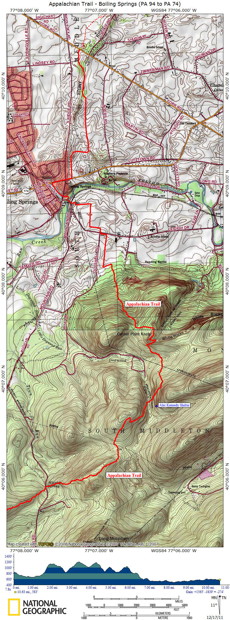
This 10.6 mile section of the Appalachian Trail in Pennsylvania features the beautiful small town of Boiling Springs. The Appalachian Trail Conservancy's Mid Atlantic Regional Field Office is located here. There is one shelter available along this stretch of trail. The Alec Kennedy Shelter was built in 1991, sleeps seven with a composting privy nearby.
This section of trail starts off PA 94 (heading northbound) and at 0.1 miles the trail travels under a power line. At 0.2 miles cross Sheet Iron Roof Road, where there is some parking available. At 0.7 miles cross a stream. At 1.4 miles cross the dirt Old Town Road and start a steep climb up Rocky Ridge. There is a view on the left at 1.8 miles.
At 2.7 miles cross Whiskey Springs Road and in less than 100 feet pass the always flowing spring. The 193 mile Mason Dixon Trail travels east from here and connects the Appalachian Trail with the Brandywine Trail. The trail ends at its eastern terminus at Chadds Ford, PA on the banks of the Brandywine River.
At 3.2 miles pass a rock outcrop with a view on the right. At 4.7 miles cross Little Dogwood Run. At 4.8 miles reach a blue blazed trail that leads 0.2 miles to the Alec Kennedy Shelter. At 5.7 miles reach Center Point Knob, the one time mid point of the AT. In another 300 feet reach the blue blazed White Rocks Ridge Trail that leads 1.3 miles to Kuhn Road.
At 7.0 miles the trail reaches the edge of a field and turns left and then right into the field. The trail turns left and soon right to cross Leidigh Road at 7.6 miles. At 8.3 miles cross Yellow Breeches Creek on a stone arch highway bridge. The only designated backpacker campsite along the AT in the Cumberland Valley is past the gate, down an old road to the east next to the railroad tracks. The trail heads through a township park and then follows along the east shore of Children's Lake.
At 8.6 miles reach PA 174, turn right and follow the road. At 8.9 miles the trail turns left off the road and enters the woods. At 10.6 miles reach PA 74 and the end of this section of trail.
Appalachian Trail Hiking Guide
Pennsylvania ** ONLY $9.99
Hiking guide with descriptions and maps for the Appalachian Trail as it travels in Pennsylvania. The guide is broken down by 14 sections of the AT. The book comes to you delivered as a pdf file via email. Use the buy now button and we will send you the file via email usually within 24 hours of receiving payment.
Appalachian Trail in Pennsylvania
PA 94 to PA 74 ** ONLY $1.50
Hiking guide with descriptions and maps for just this section of the Appalachian Trail in Pennsylvania. The guide comes to you delivered as a pdf file via email. Use the buy now button below and we will send you the file via email usually within 24 hours of receiving payment. Happy Hiking!
For more information to assist in planning your Appalachian Trail in Pennsylvania adventure, we recommend these hiking books:
Appalachian Trail Guide to Pennsylvania

Exploring the Appalachian Trail: Hikes in the Mid-Atlantic States - MD PA NJ NY

Pennsylvania Hiking Trails: Keystone Trails Association

AMC's Best Day Hikes Near Philadelphia
50 Hikes in Eastern Pennsylvania: From the Mason-Dixon Line to the Poconos and North Mountain
Backpacking Pennsylvania: 37 Great Hikes

50 Hikes in Central Pennsylvania

Hiking the Poconos: A Guide to the Area's Best Hiking Adventures

| CNY Hiking HOME PAGE | Appalachian Trail | AT in Pennsylvania | Best of the AT in PA |
contact CNY HIKING by email at contact@cnyhiking.com
(c) 2006-today CNY Hiking - All rights reserved. Any use of information from this site without permission is strictly forbidden.
