| CNY Hiking HOME PAGE | State Lands SW of Syracuse | State Lands SE of Syracuse | State Lands North of Syracuse | CNY Hiking Blog |
|
State Lands North of
Syracuse Brasher/Bombay State Forest |
|
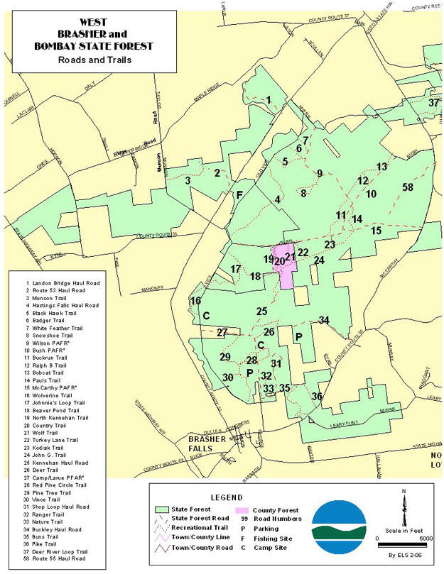
Brasher and Bombay State Forests comprise a large
reforestation area complex of 22,242 acres located near the border of St.
Lawrence and Franklin counties in the towns of Brasher, Norfolk, Bombay, and
Moira. Many people make use of the extensive trail and road system that exists through the forest. Trails are marked with signs that tell what activities they may be used for, such as hiking, cross country skiing, horseback riding, or snowmobiling. The Walter F. Pratt Memorial Forest (part of Brasher State Forest) provides a popular area for picnics and camping. A 10-acre pond was created by the CCC in the 1930's by building a dam on Redwater Creek. An association of local citizens was formed to maintain the area and promote responsible use. |
|
BRASHER FALLS TRAIL SYSTEM Snowmobile, Ski Trails The Brasher Falls Trail System is 57 miles in length and is located in the Town of Brasher. It lies primarily on Brasher State forest managed by the New York State Department of Environmental Conservation. The snowmobile trail system may be entered at several different locations. The first location is on the Meyers road off Brasher Center road (county route 53) just north of Brasher Center. Another entrance is at the easterly end of Meyers road at County Route 55. A third entrance is on the McCarthy road. To the east of the Deer River another snowmobile trail system can be entered via county road 55. Both systems have a series of interconnecting trails, which give the rider a wide selection of loop lengths from which to choose. The ski trail goes from the Bush Road southerly through the Brasher State Forest to County Road 50. Directions The system can be reached from County Roads 50, 53 and 55 north of Brasher Falls. |

| State Lands North of Syracuse | Hiking in New York State Lands | CNY Hiking HOME PAGE |