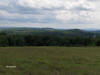
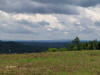
A nice 2.6 mile loop with much of the hike in open fields. There are surprising views on this hike. Elevation change of 285 feet. There are other "trails" in the forest, look at our topo map below to see the other trails. This hike can be hard to follow.
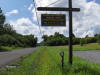
Directions: From Syracuse, NY take I-690 WEST to NY 695 South to NY 5 WEST. Take the NY 173 "Warners" EXIT. Turn left on NY 173 and go through the small village of Amboy. Turn left on Thompson Road (look for Erie Canal Towpath signs). The DEC parking area is on the right. The GPS coordinates are N43 04.183 W76 16.630.
mileage elevation Hike Description 0.0 414 feet DEC parking area on Thompson Road. Head uphill on trail.
0.1 436 feet Trail veers to the right as an unauthorized trail comes in from left.
0.15 455 feet Trail "splits". Keep right.
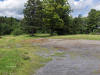
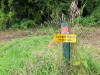
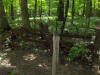
0.3 477 feet Reach old parking area located off NY 173. Trail turns to the left at end of parking area. Pass DEC sign.
0.45 464 feet Trail junction. Turn right and pass by yellow gate. Ascend. Trail will enter open field and begin to veer to the left.
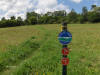
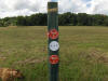
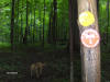
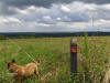
0.7 517 feet Trail post & marker in middle of field.
0.8 504 feet Reach a trail junction. Veer straight.
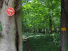
0.85 518 feet "Green Tunnel" Trail veers left between two rows of trees.
1.0 607 feet Trail Junction and Trail Post. Turn right at post. Views.
1.2 634 feet Enter forest.
1.3 665 feet Old farm equipment on left. Forest Boundary Trail on right. Continue straight.


1.5 698 feet Leave forest, veer right, then left and more views.
1.9 607 feet Trail junction & Trail Post. Turn right. Descend.
2.1 509 feet Approach trail post and "Y" junction. Stay straight.
2.2 462 feet Trail veers left and enters another green tunnel.
2.3 461 feet Trail veers left, unmarked & unauthorized trail goes right.
2.4 457 feet Reach junction and veer right.
2.45 455 feet Reach junction and veer right.
2.5 436 feet Trail turns left and heads to parking area.
2.6 414 feet Reach parking area.


