North Country Trail
Forestport to the Adirondack Park Blue Line
![]()
| NCT in Central New York | NCT in Western New York | NCT in the Adirondacks | Best of the NCT in New York | CNY Hiking HOME PAGE |
|
North Country Trail Forestport to the Adirondack Park Blue Line
|
This 6.4 mile section of the North Country Trail is currently a road walk. The NCTA CNY chapter is still looking for off road possibilities to bring the North Country Trail to (or from) the Adirondack Park Blue Line. If you know a route the trail can take off road, please contact the NCTA CNY Chapter. We have included this section of the trail for those thru hiking the 4600 mile North Country National Scenic Trail. We felt this info would be useful.
If you are thru hiking the NCT west to east, this section is the last bit of civilization before you enter the remoteness of Adirondack Park. Believe me when we tell you the NCT will be taking hikers through some remote area's in the Adirondacks. It will be over fifty miles before the trail reaches Mason Lake and NY 30. Once you leave the road at Stone Dam Trailhead, there isn't another road for vehicles that the trail reaches until the Pillsbury Mountain Trailhead after around 50 miles of remote hiking. The trail is still in the planning stages inside of Adirondack Park.
For those thru hiking the NCT from east to west, this section will be a welcomed relief and a chance to re-supply as well as eat a good meal. Luckily the trail currently passes right by the Forestport Post Office. There is a restaurant as well as a country store right along the trail and the Kayuta Lake Campground is a bit off the future trail, but check for pick up possibilities.
This sections starts at the bridge over the Black River in Forestport. To your right is the dam falls for the Forestport Reservoir. The bridge is closed to vehicles, but open for pedestrians. After 0.1 mile reach an intersection. Turn right on Woodhull Road. The "Hotel Doyle" is a few hundred feet further on River Street. The "Hotel Doyle" dates back to the 1890's and had a reputation as a rowdy bar. It is now called Scooters and is a popular biker bar.
At 0.25 miles from the Black River Bridge pass by the Forestport Post Office on your left. The Post Office phone number is (315) 392-4141 and address is 12180 Woodhull Rd, Forestport, NY 13338. At 0.35 miles pass under NY 28. At 1.1 cross Woodhull Creek. At 1.5 miles reach Bonnie's Country Store. The store phone number is (315) 392-6571. Soon after reach a road split. The NCT veers left onto North Lake Road. To the right takes you to Kayuta Lake Campground.
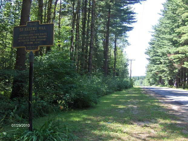
Cross railroad tracks and on your right is the Buffalo Head Restaurant. This is your last chance for civilization before entering the Adirondacks. What lays ahead are a few homes and camps. At 5.0 miles pass a historical marker for St Ledgers Hill. At 6.4 miles pass an old installation on your left and reach the sign for the Town of Ohio, marking the entry to Adirondack Park.
Below we have a few maps of this future section of the North Country Trail.
Historical marker along North Lake Road
Mileage Elevation Trail Description 0.0 1110 feet Bridge over Black River. Dam Falls on your right.
0.1 1124 feet Turn right on Woodhull Road.
0.25 1136 feet Forestport Post Office.
0.35 1151 feet Pass under NY 28. Old Forge is 25 miles to the north on NY 28.
1.1 1134 feet Cross Woodhull Creek.
1.5 1191 feet Bonnie's Country Store is on the right. Soon veer left on North Lake Road.
1.6 1198 feet Buffalo Head Restaurant is on your right. Last chance for civilization before the Adirondacks.
5.0 1401 feet Pass a histoical marker on your right.
6.4 1430 feet Reach the Adirondack Park Blue Line. The NCT continues to follow road another 1.6 miles to the Stone Dam Trailhead. The future North Country Trail is still in the planning stages inside of Adirondack Park.


| NCT in Central New York | NCT in Western New York | NCT in the Adirondacks | Best of the NCT in New York | CNY Hiking HOME PAGE |