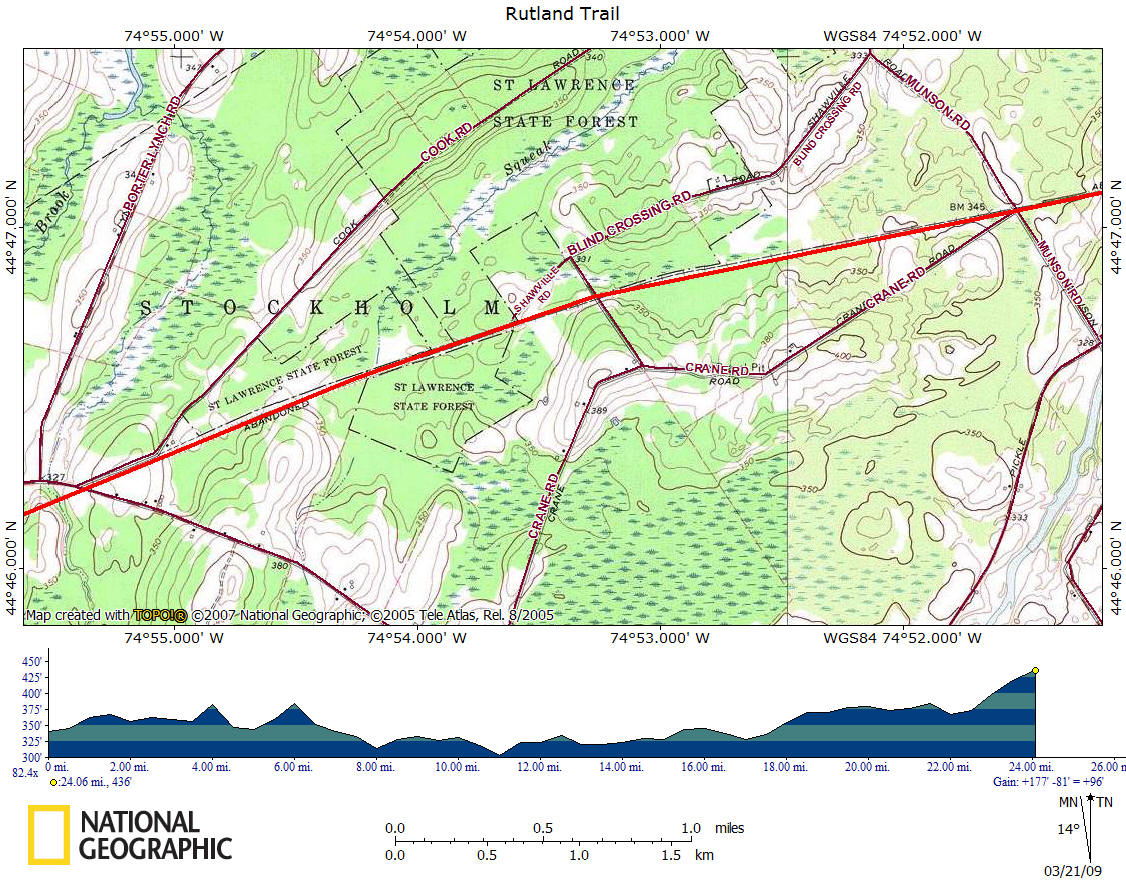
Rutland Trail
![]()
| CNY Hiking HOME PAGE | Hiking in St Lawrence County | Hiking in Central New York | Adirondack Park |
| • 5.56 NATO |
Hiking in St Lawrence County Rutland Trail
|
The Rutland Trail is a multi-use trail extending for 24.1 miles from Norwood to Moira, NY in St Lawrence and Franklin County in northern New York. The Rutland Trail is part of the remains of the Rutland Railroad Northern Division. Originally, the railroad extended across the entire northern top of New York State, from Ogdensburg in the west to Rouses Point in the east. This trail is sometimes on private property as well as public property.
The trail starts from Railroad Ave in Norwood and is continuous to Winthrop, where the bridge over the St Regis River was removed. In Winthrop you have to cross the St. Regis River on a highway bridge and skirt a half mile of rail bed that dead-ends at the bridge. The trail is open again from there into the village of North Lawrence, where the bridge over the Deer River was removed. Beyond the Deer River is a one mile section which is posted land by Breyer Yogurt. Beyond that section the trail is open to Moira.
Mile Elevation Description 0.0 340 ft In Norwood, NY. Railroad Ave. Follow trail east just south of Conrail tracks.
2.0 357 ft Cross County Route 48.
2.65 356 ft Cross Old Market Road
3.4 348 ft Cross County Route 47.
6.7 344 ft Cross Munson Road.
8.05 363 ft Cross County Route 49.
8.5 350 ft Cross Skinnerville Road.
10.25 325 ft Reach US 11. Turn right and follow US 11 south. Road walk next 1.2 miles.
10.4 332 ft Turn left on NY 420/Maple Street.
10.7 312 ft Turn left on County Route 49.
11.0 315 ft Veer straight onto Barnage Road.
11.45 319 ft Reach old railroad bed, turn right onto trail.
11.8 312 ft Cross Finnegan Road.
12.5 304 ft Cross Trout Brook on bridge.
13.7 314 ft Cross Allen Brook on bridge.
14.05 328 ft Cross Hallahan Road.
16.1 338 ft Reach NY 11C. Turn left on NY 11C. Road walk next 2.1 miles.
16.2 340 ft Turn right on County Route 52.
17.7 329 ft Turn right on Cemetery Road.
18.2 335 ft Reach old railroad bed. Turn left on trail.
19.6 368 ft Enter Franklin County.
19.9 358 ft Cross O'Connell Road.
22.25 367 ft Reach County Route 6. Turn right and follow road.
22.3 367 ft Turn left still following County Route 6.
22.95 370 ft Reach NY 95. Continue straight on old railroad bed.
24.1 403 ft Reach County Route 17 and end of Rutland Trail.

Click on the maps below for a closer look at each section of the Rutland Trail.


| CNY Hiking HOME PAGE | Hiking in St Lawrence County | Hiking in Central New York | Adirondack Park |
(c) 2006-today CNY Hiking - All rights reserved. Any use of information from this site without permission is strictly forbidden.