North Country Trail
Link Trail
Canastota
![]()
| Link Trail | Perryville Section | Cazenovia Section | Stone Quarry-Nelson Swamp | Tioughnioga WMA |
| Dugway-NY80 walk | Muller Hill-Maripossa SF | CNY Hiking HOME PAGE | North Country Trail in CNY |
|
Hiking in Madison County North Country Trail Link Trail Canastota
|
This 4.4 mile section of the Link Trail begins at its northern terminus at the junction of the Erie Canal Trail in the village of Canastota. This section of the trail features the North Country Trail (which coincides with the Link Trail during this section), the village of Canastota, Canastota Ravine, Canastota Creek and an old Lehigh Valley Railroad bed. Canastota was designated as a "Trail Town" by the North Country Trail Association in April 2013. The description of the Link Trail is north to south.
From the Old Erie Canal Trail, the trail turns left on NY 13 south, following the sidewalk and when you reach NY 5 after 0.7 miles turn right until you reach the light near Aldi's then turn left on Mount Pleasant Street. The trail veers right off Mount Pleasant Street and parallels the road. The North Country National Scenic Trail coincides with the Link Trail in this section. The trail reaches Mount Pleasant Cemetery at 1.2 miles.
At Mount Pleasant Cemetery there is parking for a few cars and the trail veers right into the woods. The GPS coordinates for the parking area is N43 03.872 W75 45.266. Please remember your hiking on private property and stay on the trail. The trail reaches an old woods road at 1.4 miles. The trail briefly follows an old woods road before turning off the road at 1.55 miles and heading back on a footpath. The trail ascends toward a trail register at 1.9 miles before descending on wooden stairs into the Canastota Ravine. There is a bench on the stairs for those who want a break and enjoy the peace of the area.
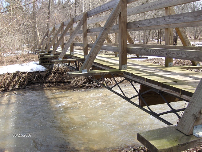
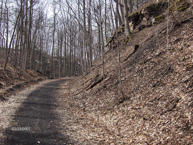
The trail follows the ravine to Canastota Creek, which is crossed on a well built footbridge after 2.0 miles of hiking. The bridge and the wooden stairs in the ravine are impressive works of construction along this section of trail. The trail will soon ascend up to the old Lehigh Valley Railroad and turns right to follow the old rail bed. The trail on the left is a spur trail that leads 0.2 miles to a small parking area off Oxbow Road.
If you look close you'll see remnants of the old railroad. On your right you see and hear Canastota Creek below. This is a very scenic section of the trail. The trail will follow along the old rail bed on its way toward Nelson Road. At 3.6 miles you reach Nelson Road and a small parking area on the side of the road. The GPS coordinates for the parking area is N43 02.558 W75 45.710. You are now following a section of trail that was bulldozed to make room for a snowmobile trail.
At 4.4 miles the trail crosses Harp Road and the end of this section. There are a couple of pictures, a map and detailed description of the trail below. Follow the blue blazes and a few yellow blazes.
Bridge over Canastota Creek
Following the old Lehigh Valley Railroad bed
Guide to Hiking the Link Trail
3rd Edition (2014) - Only $5
Guide to the 40+ mile Link Trail with description, pictures and maps of the trail. The guide comes to you as a pdf file, meaning you print just the pages you need, when you need it. Use the buy now button below and we'll email you the file usually within 24 hours.
Miles Elevation Description 0.0 427 feet Junction of Old Erie Canal Trail at Canal Street and NY 13. Follow NY 13 south, following blue blazes.
0.7 476 feet Turn right on NY 5.
0.85 459 feet Turn left on Mount Pleasant Street.
0.9 463 feet Trail veers right off the road.
1.2 491 feet Reach Mount Pleasant Cemetery. (Parking) Trail turns right into woods.
1.4 545 feet Trail turns left onto old woods road 1.55 542 feet Turn left off old woods road and back onto a footpath. 1.9 541 feet Trail Register. Soon reach stairs to descend into "Canastota Ravine".
2.0 528 feet Cross Canastota Creek on footbridge.
2.1 567 feet Reach old railroad bed and turn right, following the old railroad bed. The trail to the left travels 0.2 miles to a small parking area off Oxbow Road.
3.45 684 feet Trail Register.
3.6 702 feet Cross Nelson Road. Small Parking area.
4.4 728 feet Cross Harp Road.

| Link Trail | Perryville Section | Cazenovia Section | Stone Quarry-Nelson Swamp | Tioughnioga WMA |
| Dugway-NY80 walk | Muller Hill-Maripossa SF | CNY Hiking HOME PAGE | North Country Trail in CNY |