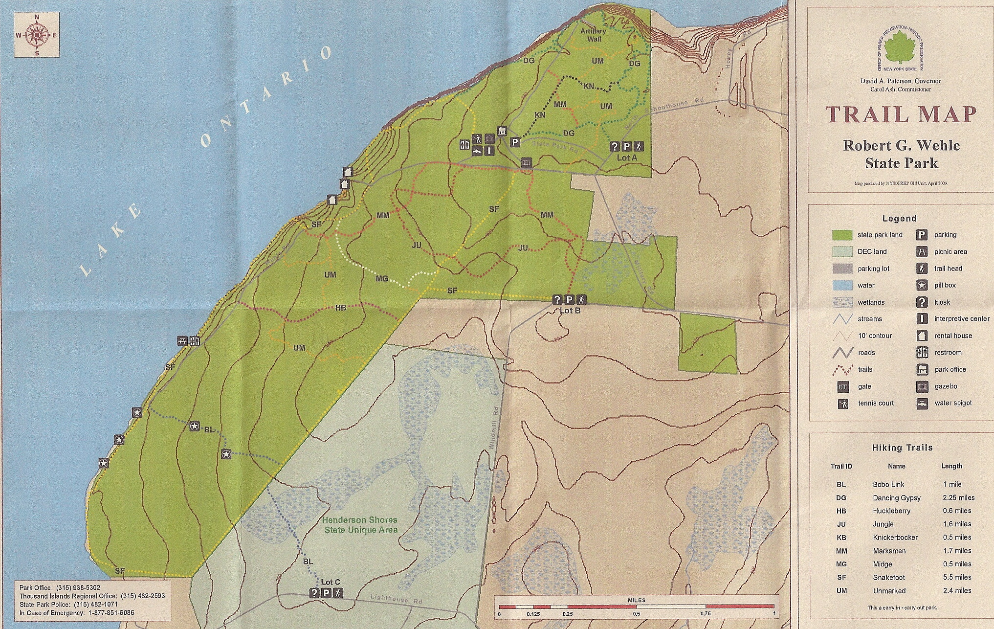
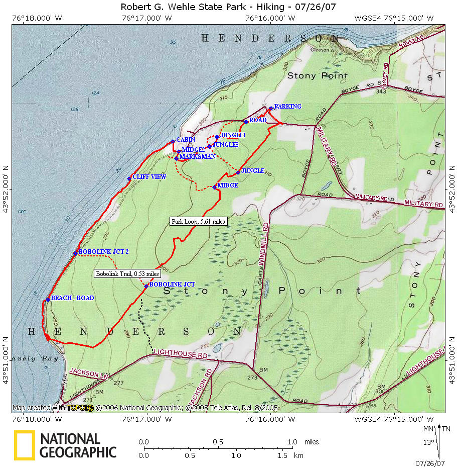
Hiking at Robert G. Wehle State Park
Snakefoot
Loop
![]()
| CNY Hiking HOME PAGE | New York State Parks | Robert G. Wehle State Park | Hiking in Central New York |
|
New York State Parks Hiking at Robert G. Wehle State Park Snakefoot Loop
|
Snakefoot Loop (5.6 miles)
From the parking area head toward the gate for the service road. Take a right at the first fork and soon on your left you will see a pole with a yellow trail marker. This is the Snakefoot Trail, turn here. At 0.5 mile reach the Jungle Trail, continue on Snakefoot Trail. At 0.8 mile reach the Midge Trail, continue on the Snakefoot Trail. The Snakefoot Trail now follows the fence line for the most part, but does veer to the right away from the fence from time to time (3x before Bobolink Trail). At 1.8 miles reach the Bobolink Trail. At this point you can either turn right on Boblink Trail or continue on Snakefoot Trail. WARNING this part of the Snakefoot Trail becomes a "bushwhack" shortly after the Lighthouse Rd Connector Trail (at least when we did this hike in 2007).
If you turn down Bobolink Trail your hike is about 4.6 miles. Turn Right on Bobolink Trail, continue to you reach the service road then turn right on road. Then turn left in a short while and your back on the Snakefoot Trail. For the rest of the hike see below AFTER the turn back on Snakefoot Trail.
Continuing down Snakefoot Trail from Bobolink, soon pass a unmarked trail on your left. This is the Lighthouse Rd Connector Trail. Continue straight ahead on Snakefoot Trail, which now almost disappears in the grass/weeds. Stay near the fence, pass a deer stand which is on private property. Soon the fence bends to the right and heads toward Lake Ontario. Soon you will be walking through a boggy section. Near the shore you will see the remnants of an old deer stand. Now you will need to find an opening to get to the shore and follow the shore for about 0.4 miles until you come to an opening that is the old service road. Follow the service road for the next 0.4 miles passing the Bobolink Trail on your right, then turn right back onto the Snakefoot Trail.
There are views of Lake Ontario throughout this section, with some great views of the cliffs along the shoreline. You will pass a picnic area with grills as well as bathrooms, then come to a cabin. Turn right here and head toward the wooden fence across the open field. When you reach the road, turn left and follow road until opening in fence. There is a trail marker here, this is Midge Trail. At your next trial junction, turn left on Marksman Trail. You will pass by the junction of Jungle Trail, then at the next trail junction (Jungle Trail again) turn right on the jungle trail. The trail almost disappears just before you enter a field, follow Jungle Trail back to the service road. Turn right on the service road and you'll start to see the parking area. You can follow the road or walk straight through the grassy (mowed) area back to the parking lot. The elevation change for this hike is minimal.
There are many other trails in this park on the other side of the parking lot. The kiosk has a map, plus there are park maps on the fence near the kiosk. Click on the images below for a look at the trail maps for Robert Wehle State Park.
| Robert G. Wehle State Park | CNY Hiking HOME PAGE |